TIWN Aug 24, 2016

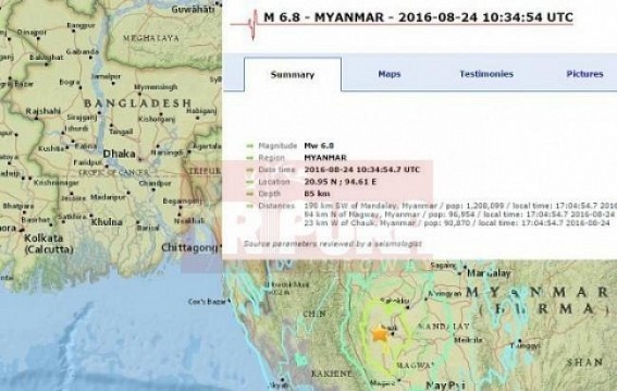
AGARTALA / DHAKA / NEW DELHI, Aug 24 (TIWN): Myanmar, Bangladesh, Northeast region including Tripura experienced a major jolt of 6.8 Richter scale at 10.34 UTC time (India Time 4.04pm). People across Tripura ran out of their homes, businesses as frequent quakes triggered panic. There were no immediate reports of injuries or damage.The magnitude-6.8 quake struck at a depth of 85 kilometers ), 195 kilometers north of Mandalay, according to the U.S. Geological Survey. Horrified people across Tripura ran out of homes, hospitals, shops to escape wrath of earthquake. Railway stations, Agartala's ancient structures reported minor structural damage, no causalities reported. A strong earthquake of magnitude 6.8 on the Richter scale jolted Myanmar on Wednesday -- the second in two days -- with its effects also felt in neighbouring Bangladesh and India's northeast and Kolkata megapolis. According to the Indian Meteorological Department, the epicentre of the earthquake was at a point 195 km south of Myanmar's Mandalay city and about 19 km west of Chauk town. The depth of the earthquake was 85 km.Tripura Govt’s disaster management preparedness yet to learn dealing with massive natural disasters like 6.8 magnitude earthquake of wednesday afternoon.
On top of that Tripura is facing major problem with ruling party backed corruptions in AMC (Agartala Municipal Corp) which in turn allowing illegal multistoried buildings like Rose Valley Chit Fund Agartala office.
Wednesday's earthquake occurred at intermediate depth of 85 km and 195km away from Mandalay, according to the USGS, which means it took place within the Indian tectonic plate as it subducts beneath Eurasia
North East India is seismically one of the six most active regions of the World, the other five being Mexico, Taiwan, California, Japan and Turkey.
In the past there were at least 17 major earthquakes with more than magnitude 7 during the period from 1869 to 1988.
Study of the Northeastern Indian’s earthquakes history and findings of seismological researches, the region is now due for a large major earthquake, which is expected in the region between the epicentre of Shillong earthquake, magnitude 8.7 of 1897 and Patkai Range & Arunachal Pradesh , Magnitude 7 of 1950 in the near future.
Earthquake hazards of North East India cannot be changed, however disaster can be mitigated.
Major devastating Earthquakes in the North Eastern Region In Past
|
Place |
Year |
Magnitude |
Remarks |
|
Cachar |
March 21, 1869 |
7.8 |
Numerous earth fissures and craters |
|
Shillong Plateau |
June 12,1891 |
8.7 |
About 1542 people died |
|
Sibasagar |
August 31,1906 |
7.0 |
Property Damage |
|
Myanmar |
December 12, 1908 |
7.5 |
Property Damage |
|
Srimangal |
July 8, 1918 |
7.6 |
4500 km2 area suffered damage |
|
SW Assam |
September 9, 1923 |
7.1 |
Property Damage |
|
Dhubri |
July 2,1930 |
7.1 |
Railway lines, culverts and bridges cracked |
|
Assam |
January 27, 1931 |
7.6 |
Destruction of Property |
|
Nagaland |
August 14,1932 |
7.0 |
Destruction of Property |
|
N.E.Assam |
October 23,1943 |
7.2 |
Destruction of Property |
|
Arunachal |
July7,1947 |
7.5 |
Destruction of Property |
|
Upper Assam |
August 15,1950 |
8.7 |
About 1520 people died, one of the biggest known quake in the history. |
|
Patkai Range, Arunachal |
August 15, 1950 |
7.0 |
Property damaged |
|
Manipur Burma Border |
March 21, 1954 |
7.4 |
Property Damaged |
|
Darjeeling |
1959 |
7.5 |
Property damaged |
|
Indo Myanmar Border |
August 6, 1988 |
7.5 |
No casualty reported |
|
Sikkim |
September 18,2011 |
6.9 |
Destruction of Property, loss of lives, 67 dead. |
The northeastern states -- Assam, Meghalaya, Mizoram, Tripura, Nagaland, Arunachal Pradesh and Manipur -- are considered by seismologists as the sixth major earthquake-prone belt in the world.
"Though the estimate of damage has not been done, this is strong magnitude quake that causes great damage to life and property," an official said.
This is second time in two days that tremors were felt in Myanmar. On Tuesday, a 5.5-magnitude earthquake in the Myanmar-India border region also rocked Assam, Tripura, Mizoram, Meghalaya and some other parts of northeast India. However, there was no report of major damage.


